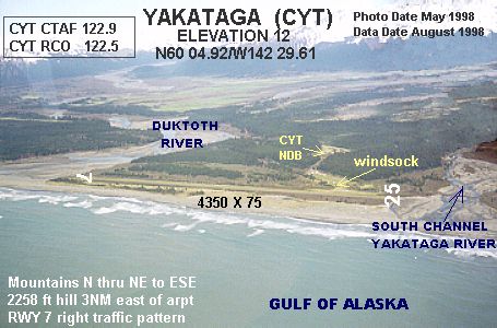
Yakataga Airport (IATA: CYT, FAA LID: 0AA1) is a public-use airport serving Yakataga (also known as Cape Yakataga) in the U.S. state of Alaska. It is owned by Federal Aviation Administration and lies in the western section of Yakutat Borough.
Scheduled passenger service to Yakutat Airport (via Alsek Air Service) ended in 2012, when the United States Department of Transportation suspended Essential Air Service subsidies.
Facilities and aircraft
Yakataga Airport covers an area of 1,115 acres (451 ha) at an elevation of 12 feet (4 m) above mean sea level. It has one runway designated 8/26 with a turf surface measuring 4,350 by 75 feet (1,326 x 23 m).
For the 12-month period ending December 31, 2009, the airport had 350 aircraft operations, an average of 29 per month: 43% air taxi, 43% general aviation, and 14% military.
See also
- List of airports in Alaska
References
Other sources
External links
- FAA Alaska airport diagram (GIF)
- Topographic map from USGS The National Map
- Resources for this airport:
- FAA airport information for CYT
- AirNav airport information for PACY
- ASN accident history for CYT
- FlightAware airport information and live flight tracker
- SkyVector aeronautical chart for PACY